Understanding The Scale of Migratory Birds’ Attraction to Artificial Light in the Era of LEDs (2026-2028)
Investigator: Kyle Horton (PI) and Carrie Ann Adams (Co-I), Purdue University, West Lafayette IN, USA
NASA Biodiversity
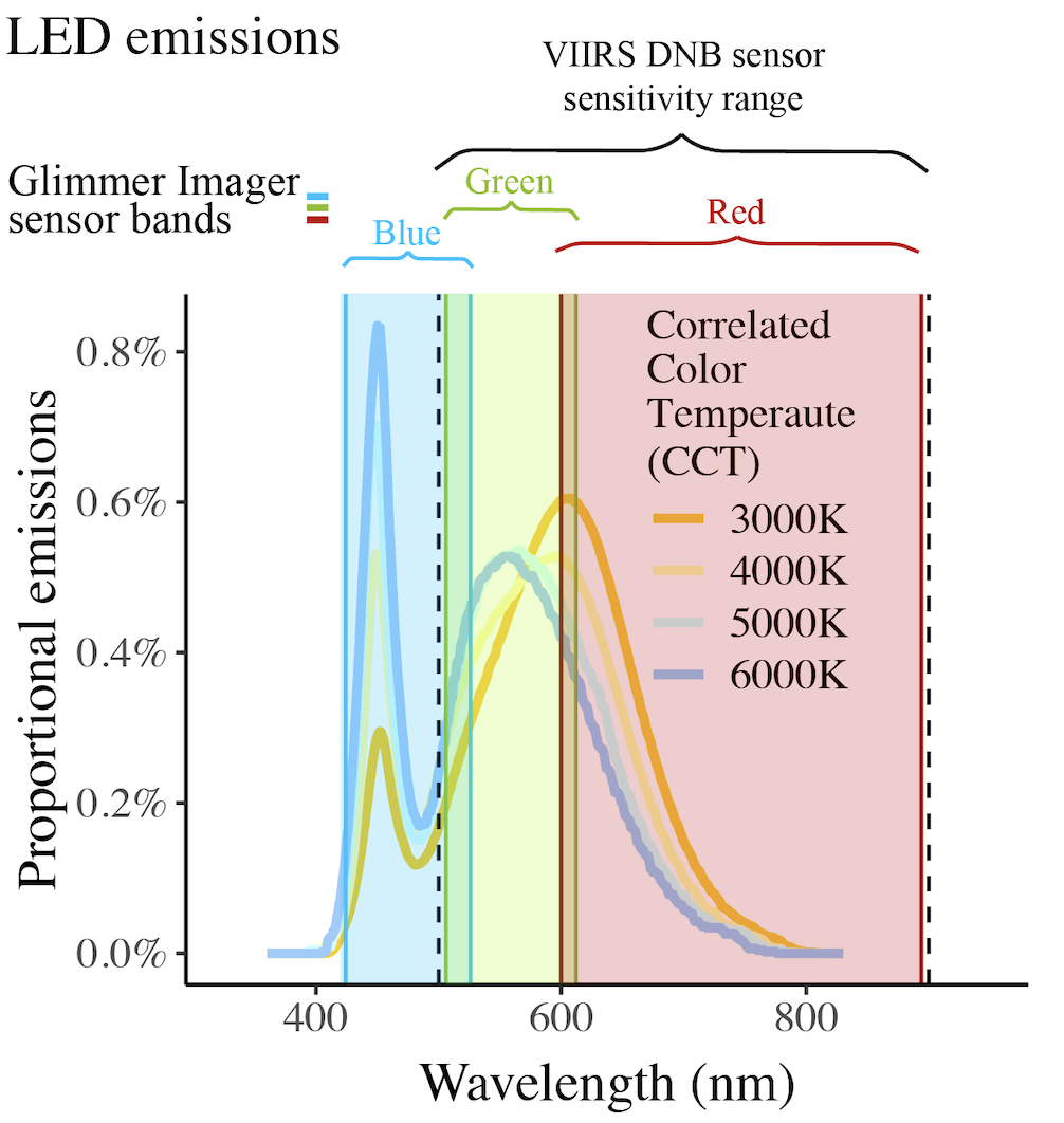
Project Summary: The ongoing replacement of older outdoor lighting with light emitting diodes (LEDs) is contributing to increased emissions of artificial light at night (ALAN), especially in the shorter (bluer) wavelengths. Blue light affects melatonin production, disrupts the diel organization of biological activities, and can increase cancer risk in animals. Many species have higher visual sensitivity to shorter wavelengths, and blue light may attract more nocturnally migrating birds and increase collision mortalities. However, our primary means to measure ALAN at a global scale — NASA’s Black Marble (BM) nighttime lights product suite — is becoming less useful for monitoring light pollution and studying its biological effects because it fails to detect most blue light. Our proposed project has two goals: (1) add value to existing NASA nighttime light products in the new age of LEDs by integrating Black Marble measures with supporting data sources to measure ALAN in multiple spectral bands; (2) leverage the enhanced nighttime light products, in combination with continental-scale data about bird migration, to understand the scaling dynamics of the biological effects of ALAN and inform bird-safe lighting policies.
Question 1: Can multiple remote sensing products be combined to produce better estimates of ALAN than any product alone? We will use radiance measurements from the red, green, and blue spectral bands of the Sustainable Development Science Satellite 1 (SDGSAT-1)’s Glimmer Imager (GI) sensor to train a neural network to create a multi-band predictive map of ALAN (MBP-ALAN) across the continental US. The neural network will make ALAN predictions, both forward and backward in time, by combining BM data with hyperspectral imagery from other NASA missions (PACE, EMIT, and DESIS) and remotely sensed metrics of other human dimensions (population, land use, and building characteristics) known to be associated with band-specific emissions.
Question 2: What are the scaling dynamics of bird attraction to ALAN radiance in red, green, and blue bands emitted from stopover habitat? We will use weather surveillance radar (WSR) to quantify stopover habitat use by migrating birds across the continental US. We hypothesize that (a) more migrants are attracted to stopover in areas with shorter wavelength (bluer) light; (b) the effect of incremental increases in ALAN diminishes as total radiance increases; and (c) light sources in rural areas attract more birds, per unit ALAN, because of higher contrast with surrounding darkness.
Question 3: How far from light sources do the effects of ALAN extend, and what proportion of the aerial habitat for nocturnally migrating birds is affected by ALAN in the continental US? Little is known about the scale of bird attraction to ALAN. We will use WSR to measure density of migrating birds in the airspace and model the extent over which ALAN in multiple spectral bands affects migrant density. We hypothesize that migrating birds are attracted to light from distances greater than 10 km, affecting a substantial portion of aerial habitat in the continental US. We further expect that the influence of red and green light diminishes with distance less rapidly than blue light, and that the distance over which birds are attracted is greater when background radiance — in the form of light pollution or moonlight — is low or absent.
Our project will produce new data products mapping ALAN in the continental US in three spectral bands and will answer outstanding questions regarding how light characteristics and surrounding lightscape affect bird attraction. These products will be invaluable for further biological research across a wide diversity of taxa, will inform policy applications to protect migratory birds and direct sustainable lighting, and will be instrumental in understanding fundamental scaling questions in macroecology and remote sensing.
Aeroecology, an emerging ecological frontier for addressing modern conservation challenges (2021-2025)
Principal Investigator: Kyle Horton, Colorado State University, Fort Collins, CO, USA
NASA New (Early Career) Investigator Program in Earth Science

CSU AeroEco Lab BirdScan radar.
Project Summary: The lower atmosphere harbors a tremendous amount of biodiversity. Each spring and fall, trillions of migratory organisms of thousands of species traverse this medium — a medium that has long been overlooked as a critical ecological habitat. Migratory organisms connect earth’s hemispheres and serve as bellwethers of ecosystem health and changing environments. Evidence of declines in migratory organisms, particularly birds, is overwhelming, highlighting an important need for research and tools that can direct conservation action to mitigate threats to these organisms. Yet most studies of associated threats for migratory species have focused on terrestrial habitats, underscoring a fundamental knowledge gap. Airspaces are increasingly becoming crowded, with more anthropogenic structures (e.g., wind turbines, high-rise building, communication towers) populating the lowest reaches of the troposphere than ever before — posing an ever-increasing threat to wildlife. In the contiguous U.S., annual fatal bird collisions with these structures cumulatively number in the hundreds of millions. Furthermore, artificial light pollution from these structures can greatly magnify this threat. The scope and scale of this concern requires a revision of our understanding of the ecology of airspace, a new frontier known as aeroecology. Yet as our recognition of airspace as a habitat grows, so must the tools to quantify, characterize, and predict the movement of organisms through these spaces. Ecological forecasting of bird movements at relevant spatial and temporal scales provides a novel, data-intensive pathway toward real-time ecological monitoring and dynamic conservation actions. Short-term conservation actions may include the temporary removal of aerial obstacles (e.g., wind turbines, aircraft) or point-source pollutants (e.g., light pollution). However, days, hours, or even minutes can make the difference between successful conservation intervention and missed opportunity. The detection of in-flight migratory birds poses a unique set of challenges, particularly because the majority of North American species migrate at night (∼80%). NEXRAD weather radar is one of the only sensors that can monitor these nocturnal movements. Moreover, it is the only sensor platform with the ability to quantify these massive movements across continental scales. However, radar alone cannot provide a predictive framework to solve the aforementioned challenges. It is through the integration with annual geospatial products that radar data can be fully realized — NASA remote sensing products fill this need.

Blackpoll Warbler
This project will integrate 15 years of NEXRAD weather radar data, NASA remote sensing data, including MODIS/Terra+Aqua land cover and vegetation indices, VIIRS Day/Night band data, and atmospheric variables to forecast nightly avian migration at the scale of the contiguous United States. This proposal will address the following hypotheses: (1) Spatial heterogeneity in the use of airspace by avian migrants is driven by atmospheric and terrestrial properties; (2) Migration forecasts are enhanced by predictors from multiple spatial domains, including perspectives from local, regional, and macroscale lens; and (3) Forecasts can be extended to unsampled areas within the contiguous U.S. as validated by a local gap-filling radar. Through this proposal, we will extend the use of NASA remote sensing products toward forecasting avian migration, deliver a tool for actionable aerial conservation, foster interactive public outreach, and train graduate and undergraduate students to form a center for aeroecology.
Opportunity: Ph.D. description and guidelines for applying.
Understanding Urban Centers as Ecological Traps for Avian Migrants (2021-2025)
Principal Investigator: Kyle G. Horton, Colorado State University, Fort Collins, CO, USA
Co-Investigator: Geoffrey M. Henebry, PhD, Michigan State University, East Lansing, MI, USA
NASA Biodiversity

Project Summary: Human populations are shifting toward urban centers. Currently, more than 80% of the United States population resides in cities — up 64% since 1950, with projections reaching 89% by 2050. Urban land area belies the outsized environmental, socioeconomic, and cultural footprints associated with city living. Cities are hotspots: of wealth creation and waste generation; of technical and cultural innovations; of greenhouse gases and toxic emissions; of impervious islands emitting heat and light; of denser human populations coupled with lower biotic diversity. Understanding the scope and impact of urban development on natural communities, both within urban areas, but also across these areas at continental scales, is pivotal for sustainable development, urban planning, and the intentional conservation of biodiversity. Remote sensing of biotic diversity has advanced considerably in the past few decades, ushering in a new era of multi-sensor synthesis, bringing together various and diverse observational datastreams to characterize, map, monitor, and model the location — and even the movement — of species and populations. We propose a novel approach to understand the influence of urban areas on bird migration by bringing multiple NASA products together with analysis of in-situ weather radar data and citizen science observations. We focus on the Central Flyway and the urban archipelago across the U.S. Great Plains. We will build our analytical dataset along a north-south transect by articulating observations from ECOSTRESS (land surface temperature and emissivity, evapotranspiration, and evaporative stress index), DESIS (a suite of complementary advanced spectral indices), and GEDI (geolocated waveforms, canopy cover fraction and leaf area index profiles) upon a backbone of time series from NLCD, MODIS, VIIRS, and Landsat. Our specialized reanalysis of NEXRAD weather radar data (>25 years) will allow us to derive system-wide measures related to nocturnal bird migration, including measures of the number of airborne migrants, phenophases of migrant passage, speed and direction of nightly movements, and migrant land use during stopover. Our inclusion of eBird citizen science measures will provide detailed daytime measures of species richness, relative occurrence, and phenology.
Wilson’s Warbler
We address the following hypotheses, which are motivated in part by urban scaling theory, about how urban areas affect migration dynamics along the Central Flyway: (1) Northward spring migration is paced by snow melt, ice-off, and vegetation green-up and southward autumn migration is paced by onset of cold and vegetation brown-down; however, urban islands of heat and other resources can interrupt the pace of migration; (2) The structure and quality (e.g., vegetation height and diversity, aboveground biomass, thermal regime and its variability) of urban habitats and their prevalence are critical factors driving spatial heterogenous landscape use of migratory birds; and (3) Light pollution emitted from larger urban areas attracts nighttime migrants disproportionately, thereby enhancing the apparent habitat quality of urban trees, parks, and act as ecological traps. With urban areas expected to grow for the foreseeable future, it is important to gain continental-scale insight now, rather than when it is too late. The emergence of new tools and data streams allows us to address critical and novel questions in the frontier of urban area development using an interdisciplinary approach.